Wednesday, August 29, 2007

Training Plan September 2007


Above is my training plan for the next four weeks. There is approx a 5-10% increase in all training times from the previous month. I have 3 challenge events during this time; a particularly busy two weeks ahead. I am viewing the 40 mile Coventry way event as the 'long day' at the MDS. This in mind I will only carry 5kg in my pack because by day 4 on the MDS that is approximately what my pack will weigh. I don't think there is any point carrying 8kg for 40 miles. It's unnecessary and will just increase the risk of injury. Plus the fact that just 6 days later I am doing another 22 mile hill event, where I do intend to carry full weight.

I've not covered 40 miles in one day before, so this is new territory for me. However, the 30 miles in Wales two weeks ago involved a considerable amount of ascent (6500ft), whereas this event has less than 2000ft. I'm thinking that the trade off in ascent will be balanced by the increased mileage and I should hopefully find the event tiring, but straightforward. I only managed 3.3mph average in Wales, but I am hoping that I can manage a 4mph average in Coventry, so I should be looking at about 10 hours on my feet. Because there are no significant hills, I am unsure how to play this one. Normally I would walk steep uphill sections and run the rest. I obviously can't run 40 miles non-stop, so I am going to have to plan a run/walk strategy. Perhaps something along the lines of; run 5 miles, walk 1 mile, repeat. This may be tiresome early on when I am fresh, but will pay me back later when I am tired. I've not quite decided for sure yet. I'll think on it this week. I'm not likely to get back home until gone 10pm on Sunday, and I will be no doubt very tired. So, expect an update on Monday.

Have a good week.

Monday, August 27, 2007

Up to The Cloud and back.

It's been an enjoyable, and (mostly) restful week. This was a 'week 4' in my training cycle, which means a recovery week. All my training times drop, giving my body time to recovery from the steady build of the last 3 weeks.

I took my usual day off from training on Monday. On Tuesday and Friday I did gym sessions, including resistance and core stability work.

On Wednesday I did a 7 mile interval session on a trail. This week I did 2 mins at pace, then 3 mins recovery, but I'll be switching that to 3 mins pace and 2 mins recovery permanently from now on. The route did include some climbing which isn't normally a part of true interval training, but since I don't have a 400M track on my doorstep it's the best I can manage.


On Thursday I did an hour long trail run, at a nice slow and steady pace. I set out to enjoy this one and not mind about the clock, deliberately going slow and steady down the hills etc to keep my time under 10 minute miles. It ended up being about 9:45. Sometimes it's hard to run this slow when your instinct is to go faster, but I read it's a common mistake that many people make to do all their training at moderate, or fast pace. To build endurance it has got to be slow and steady, even though it feels too easy. Well, I won't complain about those sessions, very enjoyable.


On Saturday I had a busy day with one thing and another and so the only time I could get a run is was by getting up at 6:30am! This was a bit of a shock to the system, since I usually run much later. Still I enjoyed it. Being a recovery week it was only an hours run. I'd forgotten how wet the fields are, soaked in morning dew, plus it was a little foggy. Visibility was about 200 metres. I went to bed early that evening, not used to such an early start.


I took Sunday as my day off instead of Monday so I could take my son out for the day. So today, Monday I planned a route that I hoped would be no more than 3 hours. 3 hours I guess sounds like a long time, but it's like a walk in the park to me these days. It's funny me saying that. My mouth would have hit the floor 18 months ago if I heard myself say that! I packed 6kg, just a little lighter than usual for this recovery week.


I drove the few miles up to Mow Cop (335m), a local folly built in 1754. I've run from, and up to this place a few times now. I parked up on the (very busy) small car park. Being a Bank Holiday it seems lots of people were taking advantage of the dry (though not sunny) weather. My route is shown below, along with the hill profile, my speed and heart rate profiles for the effort too.


The planned half way point in my route was another local peak called 'The Cloud'. It is of course the peak shown on the elevation profile above. I took this photo from near to the start point. Sweeping views over Cheshire and Staffordshire.


My route would follow a well established footpath, the Gritstone Trail for most of the approach to The Cloud. The Cloud is the hill in the centre of this shot, with the brown top.


The Gritstone trail more than lives up to its name. The first few miles were this terrain; rough boulders litter the paths. The paths for much of the test were quite testing. Mostly narrow with exposed rocks, boulders or tree routes. Full concentration required for every footfall to avoid turning an ankle. That's what trail running is all about!


A few miles in the slight bump in the overall descent is a short climb and run along the length of Congleton Edge. It's a steep sided footpath; very steep on one side as seen below!


After the descent from Congleton Edge the Gritstone Trail turns right with the Staffordshire way and heads towards The Cloud, which can be seen from a distance of a couple of miles in this photo.


Other than stopping to hope over stiles (all too frequent) or check by bearings, I made it up to the top of The Cloud with no problems. I took the back way around and up, so I could descend a different a in fact slightly steeper route. I took this decision because longer slightly less steep ascents I find more challenging than short sharp ones. This turned out to be a good decision I noted later because the descent paths was much 'picker' and would have been slower going as an ascent. Before I reached the summit though, I took the opportunity to take this shot of where I had come from, which was the highest point in this photo; Mow Cop.


I took this shot almost at the trig point at the top of the Cloud. I remember as a child I would see hang gliders buzzing around this peak, but I passed a sign on the ascent "No Hang Gliders". I suspect too many came to grief off the top (I just did a quick Google search, and there were a number of crashes apparently!).


I stood on the trig point for 20 seconds and clicked off these two shots of the panorama.


If you have good eyesight, in the very centre of the picturebelow, just before the horizon you can make out the World famous Jodrell Bank Radio Telescope. It was facing the wrong way today; otherwise it would have stood out very well in the photo.

I descended the 'picky' path and wound my way down to join the Cheshire Ring Canal Walk, and there enjoyed 40 minutes of almost elevation free running. Of course this did not last forever, and there is a wicked 700ft ascent in little more than a mile at the very end. Certainly a challenging note to end on. I did have to walk a short section in between the running effort, but overall I was very pleased with my effort on the ascent. Just before I got back to the car I took this photo of the 'Old Man of Mow'. I think I caught this just at the right angle. He looks quite creepy doesn't he? Head tilted to one side, and pointy nose.


Finally, my start and finish, Mow Cop.


The route was 14 miles and 2000ft of ascent, completed in 2 hours 50; about 4.7mph average speed. It's been a long time since I took my heart rate monitor along. I was pleasantly surprised to see that I had a nice average heart rate of 136 for the effort. This shows I am well adapted to my endurance pace. Of course I can run quicker, but this pace is the most economical for me, and the heart rate is a fair reflection of that.

So, a successful week. I will post my next months training plan in the next couple of days. I have a heavy schedule for 2 weeks now. The 40 mile Coventry Way is this coming Sunday, with the 22 mile Hills and Dales 6 days after on the Saturday. Including my normal training I expect to cover around 120 miles in the next 2 weeks. I'll post more thoughts on the next few months with the training plan update in a day or two.

Until then.

Tuesday, August 21, 2007

Rhayader thoughts, and the next 3 months challenges

Now I've had time to think about Sunday's Rhayader Mountain Trail (story below) these are my thoughts.

The Good:
The organisation was good, no problems at all. Food laid on at the start was welcome and excellent. The people at the checkpoints were superb. They brightened up an otherwise dreary day. The checkpoints were well stocked with food and all of it welcome!
I made it around the course despite problems. It crosses your mind to just quit sometimes, but you don't. So, it was character building, and should help when it comes to difficult times on the MDS. My feet stayed in one piece, a couple of places would probably have bistered if the distance was longer. This was all down to wet feet all day. GPS is wonderful.
Although I moan about walking so much in this event in some ways this is beneficial. It is the waking on the MDS that destroys feet. Runners are not used to walking, and it causes rubbing and blisters in different places. I've always know I should become a hardened walker, before a runner for success on the MDS, so I will pencil in some walking sessions into my plan again.

The Bad:
The weather - not much anyone can do about that. Falling into deep bogs and ruining my map and written route. All my fault, I guess my map case isn't as waterproof as my PDA bag. Lesson learned - pack the proper OS map because the ink won't run when wet! Wet feet all day - it's not enjoyable. I should have perhaps researched the terrain/route better, but I don't think this would have helped much.

The Ugly:
The organisers choice of route. I was annoyed because I wanted to run more and couldn't. I was very frustrated at staggering through moors and marshes with nothing resembling a path to follow. I think the organiser could have pre-warned the runners better in the event description. I accept there will always be rough ground, but there was too much normal runners (The Montrail runners no doubt knew what to expect). I don't want to walk so much.

Running out (almost) of batteries for PDA/GPS. I will take a spare PDA loaded with the same route. I can either just swap batteries, or if a PDA goes down, use my spare (recentley repaired). I need to set my GPS to low power mode to double to battery life to 17 hours+. I have event coming up that will need that kind of battery life.


The next 3 months challenge events.

Sun 02/09/2007 A Coventry Way Challenge Central England 40 miles

Sat 08/09/2007 5th Hills & Dales Northern England 21 miles

Sat 22/09/2007 In Pendle's Shadow Northern England 20 miles

Sat 06/10/2007 Grin & Bear It Northern England 25 miles

Sat 20/10/2007 John Knox Challenge Walk Central England 22 miles

Sat 10/11/2007 Six Dales Circuit Central England 25 miles

Sun 18/11/2007 Wensleydale Wedge Northern England 23 miles

Sat 08/12/2007 25th Rowbotham's Round Rotherham 50 miles

Sat 22/12/2007 Wem Winter Wonderland Central England 20 miles

The big one there is the Round Rotherham, which has been used my former MDS competitors as a warm up. Those events take me up to Christmas, when I will see where I am and target my efforts for the final run up to the event.

Sunday, August 19, 2007

LDWA Rhayader Mountain Trail.

It's the day after and I'm recovered sufficiently to tell you about my very tough and wet day in the Welsh Mountains.

[2008 report, see end of post]

Some of the misery is my fault, some is mother natures fault, and some of my misery is down the the difficulty of the route.

I got up at 5:30am. I was going to only pack 7kg, but guilt got the better of me and by the time I packed up the list of required equipment as well as a couple of bottles of mineral water for ballast, I tipped the scales at 8kg. I ate some porridge and set off for Mid Wales. It was a 100 mile journey, but only about 5 miles of that was dual-carriageway, so the going was slow. It took me just over 2 hours to get there. So I arrived about 8:15am, plenty of time before the 9am start. There were around 100 starters I believe. Not many doing the 18 or 29 mile course, with most doing 43 miles, part of the Montrail Ultra Championship. I had considered the 43, but with a 40 mile event coming up in 2 weeks, plus the slight concern of a 12 hour cut-off I decided against it. How pleased am I that I took that decision.

The event started from a village hall which was filled with runners. The walkers had left at 8am. There was cereal and toast, tea and coffee all laid on. It was very welcome as I was already hungry after the drive down. I made 3 rounds of toast and marmalade and some coffee. Then someone asked me if I was Richard? Graham, another MDS2008 competitor introduced himself to me. We have exchanged emails a few times, and he told me he was down from Scotland to take part in the 43 mile event. We had a chat and I introduced him to Anne and Vaughan who arrived, also to do the 43 miler with their super-fit dog Daisy. They (not the dog though!) did the MDS in 2006, and I met them doing La Trans Aq in June this year.

At 9am they called out the 43 milers and set them off. I wished everyone good luck.
About 5-10 minutes later, after a quick briefing from the organiser we were set off too. There were only about 10 people starting on my route. It was already raining, and had been all morning, but it was not too cold. The rain was more drizzle, than driving at this time, so I didn't wear any waterproofs for the start.

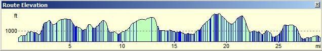
Below is the route map, with the elevation profile, and my speed profile below. For reasons I will explain later, you can more or less ignore the speed profile after the 22 mile mark.


We set off on a steady incline, quite easy and enjoyable running, all on footpaths. Two and a half miles in I got my first taste of poor terrain. I knew there was a climb nearby, but before it there was a steady incline that was in filled with stones and wood washed down form the hills above, as well as mud. It was not possible to run safely, so I slowed to my first walk of the day. We then hit the first serious climb, which was as steep as any we would face all day, just mercifully shorter. There were some small sections of rock where we had to scramble on all fours to ascend though. My pace you will see from the speed profile, drops like a stone from an average of 5mph to about 1.5mph. It was this early on I began to suspect that my 4mph estimate for the day would not happen.

At the summit of the climb we were on our first section of open moor land. This section is marked with the big red number 1 in a circle on the map, and stretching from just before CP2 to CP4, about 3 and half miles. Most checkpoints were 'Self Clip' stamping an increasingly wet piece of paper as we progressed. Up on top of that first section of moor land the terrain was mixed. Some ground was ‘runnable’, some not so. You can also see from the picture below the low cloud which came and went throughout the day. Visibility was limited all day from the peaks.

I did try to take a few picturesque shots, but the miserable weather and moor land isn't very pretty is it? What this next shot does show you is the type of terrain that set the tone for the day. Bogs, moor and marshes, and very few paths and tracks.


Just after CP3 were joined a Roman road and got a taste of better underfoot terrain, which enabled running once more. This was some of the best ground we would see all day.

I had already pulled well ahead of all the 29 milers, and was catching up a passing a few 43 milers too. A group of 3 of them were ahead of me, but a little unsure of their navigation hesitated. I had programmed the route into my PDA with GPS, and so had the route with 100% confidence. I pointed everyone in the right direction and we ran on. One of the three of them was 20m ahead when he warned us of a bog. I stopped at the edge and chose a nice patch of sturdy looking moss to leap onto. I did so and promptly went straight in up my waist. If I had not grabbed hold of the other side as I leapt I have no idea how far I would have gone in, but a lady at a checkpoint told me that she had gone in up to her waist up there, on a horse!


I wasn't to know at the time, but that fall was to play a part in the stress and misery to come. I picked myself up, and noticed as I did that my PDA had been fully submerged in the bog. However, I had purchased an Aquapac, a fully waterproof PDA holder just a couple of weeks ago. Well, it works. How I thanked my foresight good sense at that moment.


We then began to descend towards the Craig Goch reservoir as seen below, and pick up the path around it, you can just see on the second photo on the left of the water (about half way up the picture at the bottom of the rocky section.


This was a nice downhill for around 2 miles, taking me to the first manned checkpoint on the damn head of the reservoir. After a quick cup of orange juice and a couple of biscuits I was off again. I had packed some nibbles (nuts, banana chips and M&Ms and was eating those too). The good running only continued for about half a mile when we hit the next couple of serious ascents in succession, with this short section in between pictured below. Not great running, but not bad at all, in comparison to the rest of the day to come.


I took these couple of photo's on that ascent, trying to give you a flavour of the countryside, and conditions which were moderate at the time of the photos. Still drizzle, but not too bad.


At the top of the second ascent I self-clipped at CP7 (marked on map), and began the descent on my own. I had sat nav, but I was just totally unable to find the footpath about half a mile after the self clip, enabling a safe descent down the steep hill. I ended up going through ferns over my head, and stumbling down and over some rocks. This was quite hair raising, but eventually I saw the zigzagging path below me and stumbled out of the undergrowth to join it and continue to the foot of the hill, around the 9 mile mark. It was as early as this point where I recognised that I was feeling more tired that I was used to at this early stage. I was still ok, but knowing my body, I could tell the terrain was taking a heavier toll. Between the section marked 'White Cottage' and CP8 Self Clip there was my first taste of nasty and totally ‘unrunnable’ terrain. This marshland could not get my feet any wetter, which were already soaked through and would remain so all day long. The long thigh-length grass was a hindrance though. I marched through and onto a very narrow path beside another reservoir. I caught up another couple of walkers just before the CP8 self clip point and chatter for a couple of minutes. I could see 2 runners who I passed nearby. We all clipped in, and set off close together for the next section. For me it would be a hellish 5 mile ascent.


A nice woodland path soon turned into moor land. At this stage, the navigation instruction changed. No more paths or tracks, just instructions on landmarks or compass bearings. We had to follow a stream over terrible terrain. The grasses were long and in clumps. The organiser had told us that it was beyond ankle breaking, it was leg breaking territory.

This photo and video really sums up most of the terrain for much of the day; longer than knee length grass, and at least ankle deep water. This wasn't just short sections, this was for miles. You should begin to detect from my tone of voice in the video that I was starting to get unhappy. All of a sudden this was not a running event for me anymore, as I could not run on the terrain. Look at the speed profile at 11 miles, notice the marked change from then onwards, to the previous 11 miles?


The grasses were even longer in some sections, and it was all leg-breaking and miserable. Everyone forced to walk.


At 12 miles in, where the ref flag above the circled number 2 is marked, the 43 mile route splits from the 29. The 43 mile route takes a fairly straightforward route west and joins a well marked track. I have marked it with a green dotted line. So the 43 milers had that easy, but of course are brutally punished with an additional 14 miles more than me overall!

Now, I looked at my PDA and saw the next section. I remember plotting it and the instructions said head for the peak of Craig Fawr which may or may not somewhere in the picture below. You see there wasn't really a peak. Off the left and right were little peaks, but nothing you could identify as an actual peak to take a sight-reference from and walk towards. This section is the big red 2 in the circle.

I could see no one ahead and no one behind me. There was no path, just marsh and bog. The terrain was bad. All long clumpy grass. There was no runing that could be done, even though it was not steep. I began a 'stagger' towards what the GPS said was the peak. I stumbled, I sank, I fell over lots of times. I trudged wearily over horrible ground. It began to rain heavily, and the cloud dropped, further hampering efforts to head for this peak. I can't tell you how demoralising this section was. The ground was the worst I would experience all day. I went up to my waist a second time, and had to constantly weave left to right to dry and avoid the deepest bogs. There were streams and pools everywhere that had to be crossed; either jumped or forded. I didn't much care how I got across as long as I didn't go in any deeper than my knees. I had been soaked to the bone for some time, but the wind was mercifully quite low and so I had not got cold. The driving rain seemed to make the wind think it was missing out on some action. It picked up and I began to feel cold for the first time. I caught sight of two walkers ahead with a dog. They were having a tough time like me, and I caught them up after about 20 minutes.


The man told me he had run it last year, but the route was different and had not crossed this section. He also said the event was run later in the year and all the grass was much shorter and generally easer to run on. He didn't envy me trying to run this year. He had done it in 7.5 hours, which is what I had guessed at, but already knew was going to miss by a long way. I had caught them right on what passed for a cairn on the peak, and he told me the route I had planned to take down was bad. He had chatted to the organiser before and was told it was waist deep water. I thanked him for the information and picked another route down the manned checkpoint CP10. I was very cold when I got there.


The organiser was at that checkpoint and I just said "that was horrible". I think he got the message, and everyone must have said the same; it was a very hard section. I had packed a long sleeve Helly Hansen top, and so quickly changed into it. I put on my waterproof jacket, my hat and gloves too. I spent about almost 10 minutes stuffing myself with assorted cakes and biscuits, and getting warm. The checkpoints were all well stocked all day, well done to the organiser for that, and thanks to the people who sat there and got as wet as I did all day. I mixed up my first electrolyte drink too. I had been feeling quite low after that march, but felt better as I set off with some food inside me. I had already got through 70% of my nibbles. I was clearly using a lot of calories even though I had done more walking than usual.


The next section showed a track for the next 3 miles. A flat section too. Easy running I though, but the organiser said "You might be swimming the next section. I soon saw why. If it had all been like the two shots below it would have been fine. However, most of the time it was totally flooded and I had to go into the marshland on either side.


The last mile of that section to CP13 was better, and some on road. I picked up my pace again, and had also warmed up. I packed up my gloves and hat again. I passed some walkers just before CP13. I recognised their faces from the first ever LDWA event I did last year. They didn't recognise me of course, now being a runner. They told me the next section was a 5 mile ascent with very very difficult navigation. They stressed how hard the navigation was a couple of times. I didn't like to say I had GPS, so I thanked them and ran onto the checkpoint. I literally stayed 2 minutes as it had only been 3 miles from the last one, and set off one the ascent and the section marked with the big red 3 in the circle.


After a couple of miles of steady climb on good visible track, we were to take a right on a barely visible path. I was overtaken at this point by three of the 43 milers. The only people who passed me all day (three others were aleady ahead before thr routes merged). None of us saw the 'barely visible path' and over-ran it by a 1/4 mile and then took a steep path up the mountain and back onto the familiar tough moor and marsh terrain.


I've taken a close-up of the map for this section which was about 4 miles long, but felt like 10.


I had marked the route on my PDA to follow the footpath, the red dotted line. The line I actually took was the black line. You can see for the first half I did fairly well, even though there was NO PATH to be seen anyway! This section was essentially a rough moor crossing, followed by a descent into a valley, then another steep climb, all in horrible terrain.

I was very miserable and very cross at this point. I was annoyed because the terrain was so bad, and I had not felt forewarned. It was the harshest terrain I had ever experienced on an LDWA event and I was not mentally prepared for it. All due respect to the Montrail Mountain Championship people who must expect it and do it anyway (although some afterwards said it was harsher than they expected). I wanted to run more, not walk, but just had to stumble on through marshland much slower than I expected to.

This video will give you an idea of my state of mind.


On reflection now at home, those comments were too harsh. At the time I was angry and miserable at the time. This is the kind of terrain that you should expect on a fell race, so I was caught out badly really.

Sorry, that's the last photo or video I took as I was got miserable at this stage and had another major concern. I found the marked path to descent the first peak. It was wide and I could run. I got so carried away, I ran a little too far and that's is where on that close-up map you see I lost any kind of path going forward to the next peak (near where it says standing stone on the close-up map). In reality I'm not really sure there much of a path anyway, but it would probably have been easier than the route I had to take to get to the summit of Drum Ddu. It was on this tough steep ascent (at least from the direction I came at it) that I heard a noise that chilled me to the bone. The 'battery low' noise from my PDA. I had been running it with the screen too bright, compensating for it being in the waterproof bag. At that moment there was nothing in sight resembling civilisation. I opened my bag to find the backup map I had printed of the route was ruined, by the waist deep dip (or dips) into the bog. The water had seeped through the Velcro seal and the ink had run, rendering it unreadable. I then reached into my pack and pulled out the written route instructions, or rather a sodden wet lump of folded paper. Useless (lesson learned!).

I was worried at this point. All I had was a compass now, and no map to take a bearing off.

I regained my composure and formulated a plan.

I set off and took a rough heading off my GPS and then turned off the PDA to save battery. I would just turn it on every few minutes to see where I was. This is why I said that after 22 miles, ignore the speed profile. You can see it goes strange, the wave turns square, as it only got a lock every few mins. My other big worry was that maybe my Bluetooth GPS battery could give out. It had been fully charged and I had tested it to 9 hours 45 minutes. What worried me was that I had recalculated my estimated time of finish to over 9 hours. I could do nothing about that, and just hoped for the best. I struggled up Drum Ddu, getting a GPS location now and again. It was steep and I was a little weary, and of course worried. The cloud was low, and I couldn't see more than a couple of hundred yards. GPS my saviour, got me to the cairn at the peak and the self clip.

There was no path down, but I remember the instructions said descend to the left of two ravines. I managed to do that with the aid of occasional GPS and made my own route onto a road and ran down half mile to the manned checkpoint. They were such nice people at the checkpoint. They made me some tea, and I stuffed myself with more sugary food. I even sat down for a few minutes as I was feeling a bit rough at this point. They told me I was the 6th person through, the first 29 miler. The other 5 were on the 43 mile Montrail championship. I was just getting up to leave when another 43 miler came in. I did expect him to catch me up later, but I didn't see him again until the end. He had done 14 miles more than me, so I am not that surprised I guess!

I set off at a walk to finished off my second cup of tea, which I had sugar put in (I never have sugar in tea). A few minutes later I was revitalised and ran on right to the foot of the final steep climb of Pistyllgwynn. Only periodically turning on my PDA I did not appreciate that I had a tough climb coming up. I am glad of that, as I would have been really demoralised If I had known. The climb was tough, made harder by heath plants blocking the path;it was like wading through treacle. I made the summit and self clipped in and headed on a good path, then onto a bridleway and long welcome descent. I descended quickly, over 6mph, proving I had plenty of run left in me because of all the walking I had done. At the foot and the remaining 2 and half miles to the finish I ran well.

I had one moment of humour that afternoon. At the foot of that hill was wide river, the Afon Elan. It was about 30m wide I would say, and I could see it said 'Ford' on the map. I got the edge and looked across. That is wide I thought, and it looks too deep at the ford point. A 4x4 car could manage it. Plus, it was flowing quite fast. I though, wow this is pretty hardcore for an event of this type. I went 15M upriver where it was more shallow and proceeded to wade across the river. I was 3/4 of the way across when I glanced to the left and saw the large footbridge which had been hidden from my view by some trees, just 20M past the Ford! The written instructions would have set me straight, if they had not been a ball of papier-mâché. I laughed to myself, up to my knees in water and continued on and out.

The last couple of miles were plain sailing, following either road, abandoned railway or footpath. I knew the end was near and felt better. Maybe it had not been so bad after all. No, hang on, it had! I arrived at the finish, 9 hours and few minutes it had taken me. I had done 30 miles and 6504ft of ascent!! That's an average of about 3.3mph. I was first '29 miler' back. There were the five 43 milers back ahead of me. Amazingly the winner, who I believe is a very well known fell runner, did 43 miles in 7.5 hours. Hats off, and I bow at his feet. I'm told the people who finished ahead had 'reccied' the route in advance. I guess they are competing in a championship, so that's what they do. Well done to them.

I had some hot tea, but passed on a meal because I needed to get home.
If I do this in 2008, I will be prepared better, mentally and physically!

[EDIT: I did this again in August 2008. I was better prepared, and knew what to expect, so it held no surprises. I expected it to be tough in places, and it was. It was a slightly easier course than 2007, but still 30 miles with 5600ft of ascent, and still very tiring in places, coupled with low cloud, challenging terrain and heavy biting rain over the longest moor section. I packed and ended up wearing extra clothes, waterproofs and a hat too. I carried less weight overall, around 4-5kg. I completed it much faster this time; 7hrs 37. This is a tough event, not for the faint hearted, and you really need to know how to navigate and/or use GPS.]

Saturday, August 18, 2007

Rhayader Mountain Trail

At the moment I'm too tired to talk about the 30 miles of rain and bog misery I have experienced today in Wales.

I'll post the story in the next post. Sound navigation skills definately needed. I'm home now because I had my GPS (imagine mile after mile of desolate bog, moor and marsh with no visible paths in low cloud and all-day rain). Only 7 people including me out of almost 100 were back after over 9 hours (6 were 43 milers, I was the first and only 29 miler to return so far too). The others who finished were very experienced and had 'reccied' the course in advance. A very tough day. More tomorrow.

Sunday, August 12, 2007

Update, and next weekends challenge

Quick update this one as there's not a lot to tell you.

I did a 6 mile trail route on Tuesday. On Wednesday I worked late and wandered downstairs about 7:30pm feeling hungry. I rustled myself up a bowl of pasta and ate in, only to remember I'd not gone for a run! So, that put an end to the run on Wednesday, quite by accident. Eating just before a run makes me (and I'm sure everyone else) feel awful.

On Thursday I went out and did a little further than planned to make up. I did 9 miles. On Friday my usual gym session, then on Saturday I did 10 miles trail, including 1000ft of ascent. It was also a hot day about 26/27C. I made a point of running always in direct sun when possible. I would deliberately move out of the way of the shade! I'm trying to get used to suffering in the sunshine, since shade will be in short supply in the desert!

Today I had planned to do a 15 mile route, but first I took my Son to Cariba Creek, the water park at Alton Towers theme park. We stayed for a longer than I anticipated but I wasn't going to short-change his fun, so I didn't get back home until 4pm. There was no one home to baby-sit him so I had to take my rest day today, instead of tomorrow. I'll get out tomorrow evening for a couple of hours with my pack, and try and get 10 miles in to make up for today’s loss.

I have received my confirmation and route descriptions of two of my forthcoming events. The Hills and Dales is on the 8th of September. I've realised it is the week after I the 'A Coventry Way' event, which is on the 1st and is 40 miles! I'd better hope I have recovered. I plotted out the route for Hills and Dales on Memory Map, and had to phone up the organiser to tell him he'd got a map grid reference wrong! A couple of digits incorrect had put one of the checkpoints about 40 miles away from the rest. Anyway, after getting the right reference I plotted the route successfully. Yesterday I got the details for the Rhayader Mountain Trail through. This is on Saturday coming. I am doing the 29 mile route. There is a choice of 13, 18, 29 and 43; the 43 being primarily for the Montrail Ultra Running Championship, but open to anyone who can complete in 12 hours. I considered it, but with my heavy events schedule over the next few months I decided just the 29 mile route. I was just about to write that the 29 mile route has 1350M of ascent, which is what the organiser states. However, I have just checked and it's actually 1900M! I think I'll email them and let them know! That is a huge difference. I'm glad I checked it.

I'll almost certainly pack around 7kg of weight in my backpack, and not 8kg, with that new piece of information. The route will be 3 miles longer and have 600m more ascent that the Dovedale Dipper I did last weekend. That is a considerable difference. The extra distance is not an issue, but the extra 600m of ascent certainly is. I think I will struggle to keep a 4mph average over the total distance. I'll just have to see what those hills are like! I'd guess I'm looking at 7 hours 30 minutes to 8 hours 30 minutes finish, roughly.

Here is a quick preview of the elevation. The highest peak is around 19 miles and 1863ft (576m).


Speak to you next week.

Sunday, August 05, 2007

LDWA Dovedale Dipper.

Well, after the midweek update I posted, I did improve a little, but still woke up this morning with a sore throat and definitely didn't feel 100%. However, I judged I was well enough and I didn't want to miss the opportunity to do the event because of the weather. It was forecast a sunny day with temperatures 28C+, and it didn't disappoint.

[I did this event again in August 2008. See the end of this post for the result]

I loaded up my pack a little more than usual, virtually tipping the balance at 8kg. I thought, it's going to be hot, so let’s try and make this even more difficult for myself! I drove to Hartington, about a 50 minute drive and arrived about 9:30am. I was shocked to see how many cars were in the car park (read: farmer’s field). The walkers on the 26 mile route had left at 9am, and the walkers on the shorter route (I think it was 15 miles?) left at 9:30am. I went to the village hall to registered and was took back by the amount of runners. It was obviously a very popular event. There were loads of club runners, all in their T-shirts etc. I'd estimate about 100 runners. It turns out I was the last person to register, I was number 396, so I guess that's how many were doing the event in total, either walking or running.

I had taken along my PDA and loaded up the map, but forgotten to load the route itself! So, I just put it in my rucksack and picked up a route description. I had printed myself a map of the route on a 50K ordnance survey map, so I wasn't totally without direction. I did have a proper Ordnance Survey map too in case of emergency. However, the route was so well marked I hardly had to refer to the written instructions. Most of the time I could follow either runners, or later in the route pick off walkers as I ran. The route is shown below. I have also marked on the locations of the 6 checkpoints. They were all very well staffed and organised; full marks to the organisers of the event.


The horn went off at 10am and we were off. Of course no one else was stupid enough to be carrying a 8kg rucksack, so I settled myself in at the very back and kept a conservative pace of between 5 and 5.5mph initially. The route is a steady climb over farmland for the first 7 miles. I knew from the hill profile what to expect, but it was perhaps a little more draining that I had thought. As always I seem to find the first 5 miles a bit of an effort. My calves burn and I’m a little short of breath. Then after 5 miles, it all magically goes away. I took this photo at about the 6-7 mile mark


This one is taken from the same spot, looking back. You can a couple of the 100 marathon team; one shirt-off already in the heat!


I stopped very briefly at checkpoint 1(CP1) just to get a refill of my water bottle and then I was off again. I'd already picked off a few runners this early, which surprised me to be honest carrying the weight I was. I had also had to explain to a few runners, who asked, why I was carrying a big pack!

Nice views over the area.


There is a nice long downhill section after 7 miles for about a mile and a half. This was very welcome and I was well settled into the run at this point. There was a short sharp climb just before CP2 which was in the village of Longnor for those familiar with the area. The route continued a steady downhill and I picked off more runners and then there was a steady climb to CP3 at 12 miles. I was pleased to run up that hill (a long slow gradient that most runners walked), something I would not have tackled even a few months ago. Up to CP3 I had pretty much run all the way, apart from a few very short sharp climbs where I would be wasting the effort. At CP3 I saw Steph, a 2009 MDS competitor (Her blog is in my list of links). She told me she was doing the event and I stopped for 5-10 mins to say hello and chat. Nice to meet you Steph! I then refilled my bottle, and at this point poured in my electrolyte. I knew that so far the route had been straightforward and the tough stuff was yet to come.

So, I left CP3 which still left quite a climb. I continued to run it, and all the way down to the foot of Ecton Hill at the 15 mile mark. Now, I had seen this hill on a 3D simulation of the course and it looked steep! As I got closer I took these photos.

That's Ecton Hill in the distance.


This one doesn't do it justice, but I still had a way to descend into the valley before starting the ascent.


I stood at the bottom, and I can say that IT WAS VERY STEEP! The first section especially. I had been catching up walkers from about 6 miles onwards, and the ones up the hill were literally taking a few steps and then setting down! I unpacked my secret weapons, my Leki Trekking Poles. After a bit of ‘faffing around’ to get the pole length right I started my ascent. Needless to say I was walking. Absolutely no one would even attempt to run up it I doubt. I just put my head down, set my breathing to 2 steps breath in, 2 steps breath out and held that rhythm. I passed plenty of people, mostly sat down, as I climbed. A few people had one or two poles, but not that many. I think those that didn't cast envious glances. They definitely helped me on this ascent. At the top, I slipped my poles (still extended as I knew what was coming next) under my arm and descended the hill to the foot of the next.

I ran with the poles (takes some practice) for the first few hundred metres of the next ascent. It was much less steep that Ecton Hill, but did get steeper later, forcing a walk again. That hill is shown in the next photo.


I was running more or less with a few other runners. They all had a T-Shirt with the 100 marathon club on it. Not sure what that meant, but maybe they'd all done 100 marathons eh? Now, not reading the route instructions really as we approached CP4, I asked one of the runners. Is this supposed to be the 18.3 mile CP? They said yes. I said but it's a mile and half early. We've only done 17! I was cheered on a little as I thought the route might be shorter in reality. Little did I know that CP4 was 16.8 miles. I had mistaken it for CP5, which I assumed was CP6! The route between what was CP4 and CP5 was very difficult to run all of. The path was cut into the side of a hill and was very narrow indeed. It was to treacherous to run parts of. Still, a little walking was welcome as the day was indeed very hot. I took this photo along that path.


Sorry, not more photo's after that. I had apparently accidentally been phoning people whilst the phone was packed away. People could hear me running. I also must have left the camera on because my battery drained too.

I had been taking on lots of fluid, but still I was feeling a little rough; light headache and feeling hot. After CP5 (which I thought at the time was CP6 still) there was one last tough climb. I was still using my poles on the uphill’s, which helped but I was beginning to tire a little at this point, about the 20 mile mark.

After that hill, I packed away my poles knowing they would just get in the way. I would suffer the last big hill at the end (mile 25) unaided. I ran down and onto the valley floor where much to my surprise there was CP6 for real. I was gutted. I thought I only had about 2-3 miles to go. I didn't, I had 5-6. I took a drink and I think I started to crash. I felt rough. I took off my pack and sat on the floor for about 30 seconds. I then got up and grabbed a few handfuls of crisps from the CP to get some salt back in me. I also braved a bucket of water over the head which seemed to be a right of passage for that CP! A combination of all of those brought me back round, and I was off again. I had pretty much eaten all of my snacks (M&Ms, banana chips and cashew nuts), but had forgotten all about my Pepperami. If I would have had one earlier I would have been better. These have plenty of salt and fairly easy to get down with some water.

I did set off from CP6 at a run, but slowed to a walk at about 22 miles as I felt rough again. I decided that I should play it safe and do a half mile run, half mile walk for the next couple of miles. The next few miles are more or less flat; a very slight incline. The run/walk strategy seemed to work, and though I still felt ropey I managed to run ok. The bottom of my back was aching, around my kidneys. I think this was the weight of the full water bottles I was for ballast, and also the heat build-up. This added to my general feeling of ‘ropeynes’s! The flat(ish) section seemed to drag on for a little and I can honesty say I was pleased to see the final climb out. I tackled the hill without any problems at all, but I did walk it to the top. At the top there was about a mile of undulating tarmac lane to negotiate. I shuffled along a little, but my back ached. I undid one shoulder clip and rested my rucksack on just one shoulder to try and give my left kidney area some relief.

I passed quite a few more walkers, some of whom I think were on the 9:30 15 mile event! Another runner caught me up. I was glad because I was a bit unsure of the direction, having seen a sign for Hartington a few hundred metres back. He confirmed I was going the right way and we shuffled on together to the finish.

I finished in 6 hours 34 I think. I did stop for a chat with Steph though, so I guess just under 6:30 discounting that [I did it 5:05 in 2008]. I have no idea where I finished, position wise; certainly in the latter end of the runners, but by no means at the back. I sat down, thankfully dropping my rucksack to the floor. I was given a lemon drink which I went and poured salt in. I think the people at the counter thought I was a bit strange, but I figured I needed it. It tasted vile, as you can imagine.

I heard than one runner had collapsed a few minutes after he got back. I only caught a snatch of the conversation though, so I don't know what happened to him. I did see a few other runner casulaties propped up on chairs at the various checkpoints. It was obviously the heat and running too fast for the conditions that got to them. I'm sure most will have carried on after a short rest. At the finish there was a meal included, a baked potato I think. However, I didn't much feel like it so I made a fairly quick exit and drove home. My headache was worse on the way back, even after drinking my (very warm: been in the car boot all day) Rego recovery drink. I went back to my parent’s house, because my Mum was babysitting my son. My mum looked after me (ahhh, thanks Mum!). I had a headache tablet, some crisps, some ice cream and some chocolate. Oh, and a nice cold flannel for my head. One or all of those worked, because I'm pretty much fine now.

Well, I got my wish today; a hot and difficult run. About 1250m of relief in the 26.3m (that's what I got on my GPS) course, but it felt like more, especially the energy-sapping Ecton Hill. I ran all but the steepest climbs, including that 2 mile incline around CP3. That was an achievement, but I think I paid for it later on in the run where I felt rough at 22 miles. The heat was also a factor, and it was quite humid too. The heat didn't actually bother me as much as I expected it to, but I think it did take its toll on me. I averaged 4mph. This is what I had anticipated I would do, so it was a success under the conditions, and the heavier pack weight. I'm pleased that although it was hot I was mostly OK, and when I did feel rough I recognised the fact and took the time to slow down, or stop for a minute. It's going to be a whole lot hotter in the desert, so this kind of experience is invaluable. It's pushing yourself beyond your limits in the desert that puts you in a bad way/coma, as seems to happen to a few people every year!

My knees were a little sore a couple of hours ago, but they feel a little better now. I think I need to order a new pair of trainers, because I was getting that pins and needles numb feeling in my foot at some points in the race. I take this as a sign that my shoes are on their way out; the cushioning gone. These have done not far off 350 miles which is when I would look to swap them. I have been carrying more weight too.

More good news is my hamstring did not play up at all. So, taking that time out to rest has worked. Hopefully totally normal service will be resumed this week.

It’s 9:45pm, and I am now starving. I’m off to raid the fridge.

Have a good week!

EDIT [I did this event again in 2008. I arrived late, setting off 50 minutes later than the other runners. I completed it in 5:05 (the organisers have me down as 5:09. I went to the loo after registering late, so they must have started the clock before I went!!). Either way it's a huge improvement on 2007, an hour and a half faster. This time I only carried a 2kg pack, and not a 8kg one like last year mind you. 5.1mph average, and I lost some time with GPS problems or I would have completed it at least 5 minutes faster for a 5 hour finish]

Thursday, August 02, 2007

Under the weather

Just a short update this one. I have been out for a run for the last 3 days, after taking Monday off as usual.

I've had the sniffles a little for the last few days. Not terrible, just a bit of a runny nose. I've obviously got some kind of cold virus, and my immune system is a bit low.

I did a 6 mile trail on Monday at moderate pace. It was tough going, tougher than usual. In fact tougher than it should have been. I just didn't have as much breath in me. I managed it, but it wasn't enjoyable. I should have taken that as sign as either had a day off or an easy day on Tuesday. Instead I did at 6.5 mile interval session. 10 minutes slow pace warm up, followed by intervals of 2 mins fast, 3 mins recovery. Once again this was on a trail route, so demanding but not too steep. Again, this wore me out more than it should and I was pleased to get home. Both days I was conscious of my hamstring. It was tight, but not too bad. I stretched it out a couple of times at stiles, and always afterwards.

It had been too tough. I decided I was run-down. I broke out the fizzy energy-booster vitamin sachet, and the zinc tablets. The only thing I could do now was to try and boost my immune system.

I woke today, Wednesday. The sniffles had gone to be replaced with a sore throat. I hit the vitamins and zinc again, and did another 6.5 mile trail run. This time it was all at a much slower pace; nice and easy. I'd say no more than 9.5 minute miles. The course was tougher underfoot, as well as elevation. I still felt tired too easily, but my hamstring wasn't as tight. Still, I could feel it wasn't right still.

Really I should have taken today off (and probably the two previous days!), but with resting last week you feel obliged to pick up again. Good sense tells me that with a healing hamstring and being run-down I should not even do the 26 mile Dovedale Dipper on Sunday. There are plenty of steep climbs (all in for 1250 metres) which is going to turn the screw on that hamstring. I'll do my gym session tomorrow, but rest up on Saturday and see how I feel.

I'll update this on Sunday evening more than likely.

Note to self: 300 miles on this pair on trainers so far.